May 2006 Java earthquake
 |
|
| Date | 27 May 2006 |
|---|---|
| Magnitude | 6.2 Mw |
| Countries or regions affected | Indonesia |
| Casualties | 5,782 dead 36,000+ injured [2] |
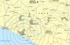
The May 2006 Java earthquake occurred at 05:54 local time on 27 May 2006 (22:54 GMT 26 May), in the Indian Ocean around 25 km (15 miles) south-southwest of the Indonesian city of Yogyakarta, near Galur, on the southern side of the island of Java (), 10 km below the seabed, with a magnitude of 6.3, according to the U.S. Geological Survey.[1] Two aftershocks, measured at 4.8 and 4.6, occurred between 4 and 6 hours later.
Contents |
Casualties
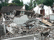
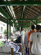
The quake caused 5,782 deaths, while 36,299 people were injured, 135,000 houses damaged, and an estimated 1.5 million left homeless.[2] 3,580 of those deaths and more than 1,892 injuries occurred in the area of Bantul, while 1,668 others died in villages in the southern parts of Klaten district.[3] Around five million people live within 50 km of the epicentre.[4]
Residents as far inland as Yogyakarta and Klaten fled inland in fear of a repeat of the 2004 tsunami, but such an event did not transpire. The Solo-Yogya highway was jammed with people fleeing in panic. Burglaries occurred during that time, leading to speculation that thieves had spread rumors of a tsunami in areas 100 m above sea level. Fear of loss through theft had also been a significant factor in the reluctance of many people living near Mt. Merapi to be evacuated when the volcano showed high activity earlier in the year.
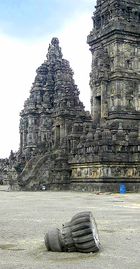
Damage was not strictly a function of distance from the epicenter. Some areas of downtown Yogyakarta were hardly affected, while parts of Prambanan, which is over 10 km further from the epicenter, were severely hit. In particular, buildings alongside the Solo-Yogya road, including the ancient complex of Hindu temples, suffered substantial damage.[5][6] As of November 2009, part of the temple complex was still cordoned off while reconstruction work continued.
The quake destroyed 148 schools and damaged 537.[7]
Origin
The earthquake is thought to have been tectonic in origin and not directly associated with the ongoing eruption of nearby Mount Merapi, although the earthquake is reported to have caused increased activity in the volcano.[8] The isle of Java lies on the boundaries of the Australian plate and the Eurasian plate. This position places it on the Ring of Fire and predisposes it to common earthquakes and other tectonic activity. The interaction of the two plates below the surface of the Earth caused this earthquake.
The sea south of Java is historically associated with many earthquakes, as indicated in the Historic Seismicity map of the USGS.[9] During 2006, there were a couple dozen quakes of similar strength off the coast, but most of them were deeper or further from shore, thus less damaging to people and infrastructure.[9]
Response
Although Tsunami warnings were issued in the early aftermath of the earthquake, the earthquake did not cause any tsunami activity.
Political
President Susilo Bambang Yudhoyono moved the army to the central Java province to aid rescue efforts and the evacuation of victims. A team of Cabinet Ministers was also sent to oversee the operations.
International aid
Many countries and organizations offered foreign aid to the devastated region, but the actual amounts delivered/received often varied from these figures, as in the case of other disasters.
- Japan promised $10 million USD, sent two medical teams and also announced that it will send troops to help out[10]
- The United Kingdom offered four million pounds ($7,436,800 USD)[10]
- Saudi Arabia promised $5 million USD, plus food, medical equipment and tents, while the United Arab Emirates and Kuwait each pledged $4 million USD[10]
- The European Union offered three million euros ($3,800,000 USD)[11]
- The United States offered $5 million; US military joins relief effort[12]
- Australia offered 7.5 million Australian dollars ($5,675,000 USD) in aid relief, including 27 member medical team among over 80 personnel[13]
- The Church of Jesus Christ of Latter-day Saints (Mormons) donated $1.6 million USD worth of emergency supplies to devastated areas, teaming up with Islamic Relief Worldwide who provided the transportation. In addition, local Indonesian LDS members prepared thousands of meals, hygiene kits, cots, mattresses, and blankets for those requiring medical attention.[17]
- The Netherlands promised 1 million euros in May plus an extra 10 million euros one month later, Belgium has pledged $832,000, while Norway, France and Italy have offered either medical teams or relief supplies[10]
- The Red Cross, Red Crescent, OXFAM, Plan International, Jesuit Refugee Service alongside other NGOs and UN agencies, including WFP and UNICEF, provided plastic sheeting, tools and building materials, and cash assistance to the victims.[11] Japan and Malaysia are to send medical teams to the affected region[18]
- Singapore offered humanitarian relief assistance in the form of a 35-member Armed Forces Medical Team, a 43-member Civil Defense Force Disaster Assistance and Rescue Team, as well as $50,000 USD worth of emergency supplies[19]
- The United Nations World Health Organization sent medicines and communications equipment, enough emergency health kits to last 50,000 people three months, and surgical kits for as many as 600 operations[20]
- The Isle of Man offered £30,000 (US$56,291) to Indonesia[22]
- King Abdullah II of Jordan ordered to dispatch a plane laden with humanitarian relief to alleviate the suffering of Indonesian earthquake victims that hit Java. The aid included blankets, medicines and other medical equipment.[23]
- MERCY Malaysia (http://www.mercy.org.my/read.php?id=24) sent 6 Missions to Jogja the first being sent on the 28th of May 2006. Datuk Dr. Jemilah Mahmood, President of MERCY Malaysia (Mission Leader) and Saiful Nazri, Programme Officer from MERCY Aceh Office went there on the first mission travelling by a special United Nations Humanitarian Air Services (UNHAS) flight from Banda Aceh along with other international organisations based in Aceh and two (2) tonnes of medical supplies contributed by the international agencies from Aceh. The first team had secured ground logistics for the subsequent teams coming in from Kuala Lumpur.
- Eric Edmeades, a Canadian Entrepreneur and CEO of KernerFX, a Lucasfilm spinoff, was traveling in Bali at the time of the quake. He immediately rented a truck, filled it with food, water and medical supplies and—against government advice—went to Jogja to undertake first hand relief work.[24]
Media
Most international wire services have already had reporters or 'stringers' in the area due to the Mount Merapi eruption to the north of Yogyakarta.
Yogyakarta for many is associated with Borobudur and Prambanan, even though both locations are some distance away from the town. As a result, news stories tend to emphasize the condition of those places. Borobudur suffered no damage whereas Prambanan, which is much closer to the epicentre, has according to reports,[5] suffered significant damage.
The reporting of the immensity of the problems that are daily evolving following the earthquake is also competing with the crisis in East Timor (Timor Leste) in the media of some countries like Australia and New Zealand.
Reconstruction
The earthquake's shallow depth was a major factor, but the scale of the damage was made worse by failure to meet safe building standards and employ basic earthquake-resistant construction methods, according to FuturArc. Most homes in the area were built with low-quality materials without structural frames and reinforcing pillars. Many deaths and injuries occurred when buildings and walls collapsed.
The government was slow to implement assistance in reconstructing private houses, leading many homeowners to repair or rebuild their homes either by themselves or with community help. Reconstruction in some areas was aided by relief agencies, like the Red Cross Red Crescent.
Villagers rebuilt their homes with extremely limited resources, using simple affordable materials. They turned to traditional materials, such as bamboo, because of the damage inflicted by collapsing brick walls.
See also
- July 2006 Java earthquake
- 2004 Indian Ocean earthquake
- Sidoarjo mud flow
References
- ↑ http://earthquake.usgs.gov/eqcenter/eqinthenews/2006/usneb6/
- ↑ "Indonesia lowers quake death toll". CNN. 2006-06-06. http://edition.cnn.com/2006/WORLD/asiapcf/06/05/indonesia.quake/. Retrieved 2006-06-06.
- ↑ "Indonesia quake death toll passes 5,800". Forbes. 2006-05-31. http://www.forbes.com/finance/feeds/afx/2006/05/31/afx2782565.html. Retrieved 2006-05-31.
- ↑ "Global Disaster Alert and Coordination System". European Commission DG JRC. 2006-05-27. http://www.gdacs.org/reports.asp?eventType=EQ&ID=18803&system=asgard&location=IDN&alertlevel=Red&glide_no=EQ-2006-000064-IDN. Retrieved 2006-05-27.
- ↑ 5.0 5.1 Sebastien Berger (2006-05-30). "An ancient wonder reduced to rubble". The Sydney Morning Herald. http://www.smh.com.au/news/world/an-ancient-wonder-reduced-to-rubble/2006/05/29/1148754940170.html. Retrieved 2006-05-30.
- ↑ "Candi Prambanan Kena Gempa". detikcom. 2006-05-27. http://www.detik.com/beritafoto/public/index.php?fuseaction=detik.readfoto&tahun=2006&bulan=05&tgl=27&time=204037&idnews=603289&idkanal=157&id=1. Retrieved 2006-05-30. (Indonesian)
- ↑ [1] Hariyadi, Mathias. "A year after the quake in Yogyakarta people still live in tents and bamboo buildings." Asianews. May 29, 2007. Retrieved May 8, 2009
- ↑ Sukarsono, Achmad (2006-05-27). "Indonesian quake kills thousands". http://www.swissinfo.org/eng/international/ticker/detail/Indonesia_quake_toll_passes_4_600_official.html?siteSect=143&sid=6754936&cKey=1148728158000. Retrieved 2006-05-27.
- ↑ 9.0 9.1 http://neic.usgs.gov/neis/eq_depot/2006/eq_060526_neb6/neic_neb6_h.html
- ↑ 10.0 10.1 10.2 10.3 "Aid pledges for Java victims rise". BBC News. 2006-05-29. http://news.bbc.co.uk/1/hi/world/asia-pacific/5027698.stm. Retrieved 2006-05-29.
- ↑ 11.0 11.1 "Aid offers pour in for Java quake". BBC News. 2006-05-28. http://news.bbc.co.uk/1/hi/world/asia-pacific/5023934.stm. Retrieved 2006-05-28.
- ↑ "U.S. Military Joins Indonesia Quake Relief". CBS News. 2006-05-31. http://www.cbsnews.com/stories/2006/05/31/ap/world/mainD8HUGLJO0.shtml. Retrieved 2006-05-31.
- ↑ "Australia send 80 skilled personnel to Yogyakarta". Antara. 2006-05-31. http://www.antara.co.id/en/seenws/?id=13562. Retrieved 2006-05-31.
- ↑ "China to offer 2 mln dollars aid to quake-hit Indonesia". People's Daily Online. 2006-05-28. http://english.peopledaily.com.cn/200605/28/eng20060528_269145.html. Retrieved 2006-05-28.
- ↑ "Ottawa pledges $2M to Indonesia quake victims; no Canadians reported affected". Maclean's. 2006-05-27. http://www.macleans.ca/topstories/news/shownews.jsp?content=n052721A. Retrieved 2006-05-28.
- ↑ "India steps up aid to Indonesia". The Hindu. 2006-05-29. http://www.hindu.com/2006/05/31/stories/2006053109001200.htm. Retrieved 2006-05-30.
- ↑ "Mormons Donate for Indonesia Earthquake Relief". The Church of Jesus Christ of Latter-day Saints Newsroom. 2006-05-31. http://www.lds.org/newsroom/showrelease/0,15503,3881-1-23473,00.html. Retrieved 2006-05-31.
- ↑ "All our students in Yogyakarta safe". The Star, Malaysia. 2006-05-28. http://thestar.com.my/news/story.asp?file=/2006/5/28/nation/14376266&sec=nation. Retrieved 2006-05-28.
- ↑ "Singapore's aid teams arrive in quake-hit Java". Channel NewsAsia. 2006-05-28. http://www.channelnewsasia.com/stories/singaporelocalnews/view/210757/1/.html. Retrieved 2006-05-28.
- ↑ "UN health agency rushes aid to quake-struck parts of Indonesia". UN News Centre. 2006-05-29. http://www.un.org/apps/news/story.asp?NewsID=18657&Cr=Indonesia&Cr1=quake. Retrieved 2006-05-30.
- ↑ "Vietnam sends rice aid to Java quake victims". VietNamNet Bridge. 2006-05-31. http://english.vietnamnet.vn/social/2006/05/576275/. Retrieved 2006-05-31.
- ↑ "Island aid for Indonesia". Manx Radio. 2006-05-31. http://www.isleofman.com/locallife/news/manxradio.asp?SCat_Id=1. Retrieved 2006-06-01.
- ↑ "King orders dispatch of aid to Indonesian Earthquake Victims". Petra News Agency (Jordan). 2006-05-31. http://www.petra.gov.jo/nepras/2006/May/31/106.htm. Retrieved 2006-06-01.
- ↑ "Earthquake Relief Work; For Real". TravelBlog. 2006-05-31. http://www.travelblog.org/Asia/Indonesia/Java/Yogyakarta/blog-64641.html. Retrieved 2006-06-01.
External links
- American RedCross site: Earthquake in Indonesia
- 'USGS Earthquake Hazards Data and Maps'
- 'USAID Responds to Earthquake in Yogyakarta and Central Java'
- May 2006 Java Earthquake Wiki - Information from the World Wide Help Group
- 'Yogya Earthquake Updates' - UN's official website on Java earthquake
|
|||||||||||
|
||||||||